
Mollie Gaines
PhD student
Email: mdgaines@ncsu.eduField of Research:
Surface Water Dynamics, Data-Driven Modeling, Climate Change, Land Cover/Land Use Change, Population Dynamics, Social Vulnerability
Biography:
I am a PhD student with the Center for Geospatial Analytics at North Carolina State University.
Research
Current Work
I am currently in the final stages of writing the first chapter of my dissertation: Effects of Climate and Human Drivers on Surface Water Change in the Southeastern United States. In this paper, I am exploring the differences in the ability of three different groups of drivers to estimate surface water change in the Southeast - climate, anthropogenic, and the combination of the two. The Southeast is an interesting study area both because of its high population growth rate - the highest of any region in the country! - and because of its large amount of land cover change. It also experiences a wide range of effects from climate change, with a hurricane season in the late summer and early fall, increased rainfall in the winter, and increasingly regular dry spells and even droughts in the summer. The data-driven models I am developing using a combination of statistical and machine learning techniques can indicate which group of drivers explains the most amount of variance in surface water across the region, as well as which individual variables are the most important in estimating surface water area.

Past Work
NOAA Internship
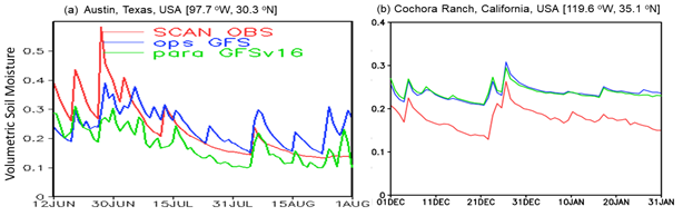
In the summer of 2020, I was selected as a William M. Lapenta National Weather Service (NWS) Intern in the Environmental Modeling Center (EMC) at the National Oceanic and Atmospheric Administration (NOAA). I work with Dr. Helin Wei and Dr. Youlong Xia to develop a script to automate retrospective and real-time evaluations of the Global Forecasting System (GFS) V16's soil moisture product (GLDAS) using the International Soil Moisture Network. These evaluations were used to determine how the soil mosisture estimates from GFS V16 compared with ground truth data as well as with other models. From these comparisons, potential reasons for differences (spatial mismatch, soil type, different ET estimations, missing physical processes, and surface meteorological forcing errors) were identified. Despite these differences between GLADS and the in-situ observations, it was concluded that "GLDAS reasonably captures the observed daily variability well. Therefore, GLDAS has been included in GFSv16 for an operational implementation at NCEP in March 2021" (Xai, Y. et. al., 2021 [in prep.]).
ORNL Internship
In the summers of 2018 and 2019 I worked with Dr. Christa Brelsford at Oak Ridge National Laboratory in the Geospatial Information Science and Technology group and the National Security and Emerging Technologies group, repectively for each summer. We assessed spatial and temporal changes in heterogeneity and scale of income and access to infrastructure services – water, electricity, sanitation, and housing – in South African metropolitan areas between 2001 and 2011.
Abstract: In an increasingly urban world, meeting the United Nations’ Sustainable Development Goals requires a rich understanding of urban dynamics – particularly in developing countries. City size probabilistically determines many aspects of sustainable development, such as household income, through scaling relationships. We hypothesized that city size also relates to levels of access to infrastructure services such as water, electricity, sanitation, and housing. In this study, we focused on the spatial heterogeneity of infrastructure access in South Africa’s major cities. Our study assessed, for the first time, the temporal dimensions of urban heterogeneity and scale in a developing country. We used South African census data from 2001 and 2011 to calculate a Sustainable Development Index centered on infrastructure access. We also calculated aggregate household income and population size for each neighborhood. To calculate heterogeneity of infrastructure access within cities, we analyzed the variance and spatial distributions of neighborhood Index values within each metropolitan area. To calculate heterogeneity of income, we calculated the Gini Coefficient for each metropolitan area based on the aggregate income of their neighborhoods. We discovered that there was a significant increase in Index values and a significant decrease in variance (p-values < 0.01 and < 0.001 respectively). Thus, infrastructure access increased and equity in the distribution of access improved between 2001 and 2011, as city size increased. These results increased our understanding of urban dynamics in a developing country and provided a quantitative analysis of urban systems important to measure progress toward the Sustainable Development Goals.


Undergraduate Honors Thesis
In my final year and a half at William & Mary, I worked with Dr. Dan Runfola to develop a drought vulnerability index for South Africa based on social and biophysical characteristics.
Abstract: Using census data from the 2011 South African census and precipitation data from the National Oceanic and Atmospheric Association (NOAA), a multi-criteria index ranking the relative climate vulnerability to drought of areas in South Africa was created. The index was developed by aggregating social characteristics into a Social Vulnerability Index (SoVI) using a principle components analysis (PCA), and aggregating biophysical characteristics into a standardized precipitation index (SPI) representative of drought risk. These separate indices were then aggregated using a Pareto Rank Order to determine the overall vulnerability of areas relative to other areas in the country. The resulting index was able to identify the Western Cape province, including the city of Cape Town, as a highly vulnerable area. In light of the recent drought and its severe impacts on Cape Town, the use of these methods to quantify vulnerability social and physical vulnerability and combine these to indicate overall vulnerability is supported. Additionally, these methods can highlight differences in the vulnerabilities of groups within larger communities when it is applied to a neighborhood scale.


Publications:
Gaines, M.D., Tulbure, M.G., Perin, V. (2021). The effects of climate and human drivers on changes in surface water in the Southeastern US. [in prep].
Xia, Y., Wei, H., Gaines, M.D., Meng, J., Gayno, G., Lei, H., Yang, R., Wu, Y., Yang, F., Barlage, M., Kleist, D.T., Tallapragada, V.S. (2021). Preliminary Comparison and Evaluation of Soil Moisture Produced in NCEP Global Land Data Assimilation System (GLDAS). WMO WGNE Blue Book. [in prep].
Perin, V., Tulbure, M.G., Gaines, M.D., Reba, M.L., Yaeger, M.A. (2021). On-farm reservoir monitoring using Landsat inundation datasets. Agricultural Water Management. Volume 246. 106694, ISSN 0378-3774, DOI: https://doi.org/10.1016/j.agwat.2020.106694.
Xia, Y., Wei, H., Meng, J., Gayno, G., Lei, H., Yang, R., Wu, Y., Yang, F., Barlage, M., Kleist, D.T., Tallapragada, V.S., and Gaines M.D. (2021). Preliminary comparison and evaluation of soil moisture simulated in GFSv15 and GFSv16. [Poster]. American Meteorological Society 101st Annual Meeting. Online. https://ams.confex.com/ams/101ANNUAL/meetingapp.cgi/Paper/378593
Gaines, M.D., Tulbure, M.G., Perin, V. (2020). The effects of climate and human drivers on changes in surface water in the Southeastern US. [Poster]. American Geophysical Union Fall Meeting 2020. Online. https://agu2020fallmeeting-agu.ipostersessions.com/?s=54-6C-58-00-15-40-46-A0-08-5A-A3-52-94-55-85-9E
Yoshizumi, A., Coffer, M.M., Collins, E.L., Gaines, M.D., Gao, X., Jones, K., McGregor, I.R., McQuillan, K.A., Perin, V., Tomkins, L.M., Worm, T., Tateosian, L. (2020). A Review of Geospatial Content in IEEE Visualization Publications. IEEE VIS Short Paper Proceedings. URL: https://arxiv.org/abs/2009.03390
Gaines, M. & Tulbure, M. (2020). Effects of climate and human drivers on surface water change. [Poster]. University Consortium for Geographic Information Science Symposium 2020. Online. https://ucgis.memberclicks.net/symposium-2020-poster-gallery
Gaines, M. "Calculating a Drought Vulnerability Index for South Africa based on Social and Biophysical Characteristics" (2019). Undergraduate Honors Theses. Paper 1380. https://scholarworks.wm.edu/honorstheses/1380
Our Team
-

Associate Professor Mirela G. Tulbure
I am an Associate Professor with the Center for Geospatial Analytics.
-

PhD student Mollie Gaines
I am a PhD student with the Center for Geospatial Analytics at North Carolina State University.
-
PhD student Vinicius Perin
Hey all ! I am a PhD student at the Center for Geospatial Analytics at North Carolina State University.