
Valentin Heimhuber
PhD Student
Email: valentin.heimhuber@unsw.edu.auOffice address:
Room 642, D26 Building UNSW, Kensington 2052
Primary supervisor: Mirela G TulbureJoint supervisor: Mark Broich
Research title: Modelling surface water dynamics on large river basin scale from space: A case study for the Murray-Darling Basin of Australia
Field of Research:
Spatial Methods in Hydrology, Geospatial Analysis, Flood Modelling
Biography:
As a result of his PhD work Tino got a hydrology Post Doc job at UNSW.
As a researcher, I am interested in the application of Earth observation data, remote sensing and statistical modeling for improving water resources management on globally significant scales. I am particularly passionate about the important role of innovative research and technology in providing the scientific evidence that is urgently needed for addressing the proliferation of the global freshwater crisis by informed policy making.
CURRENT WORK
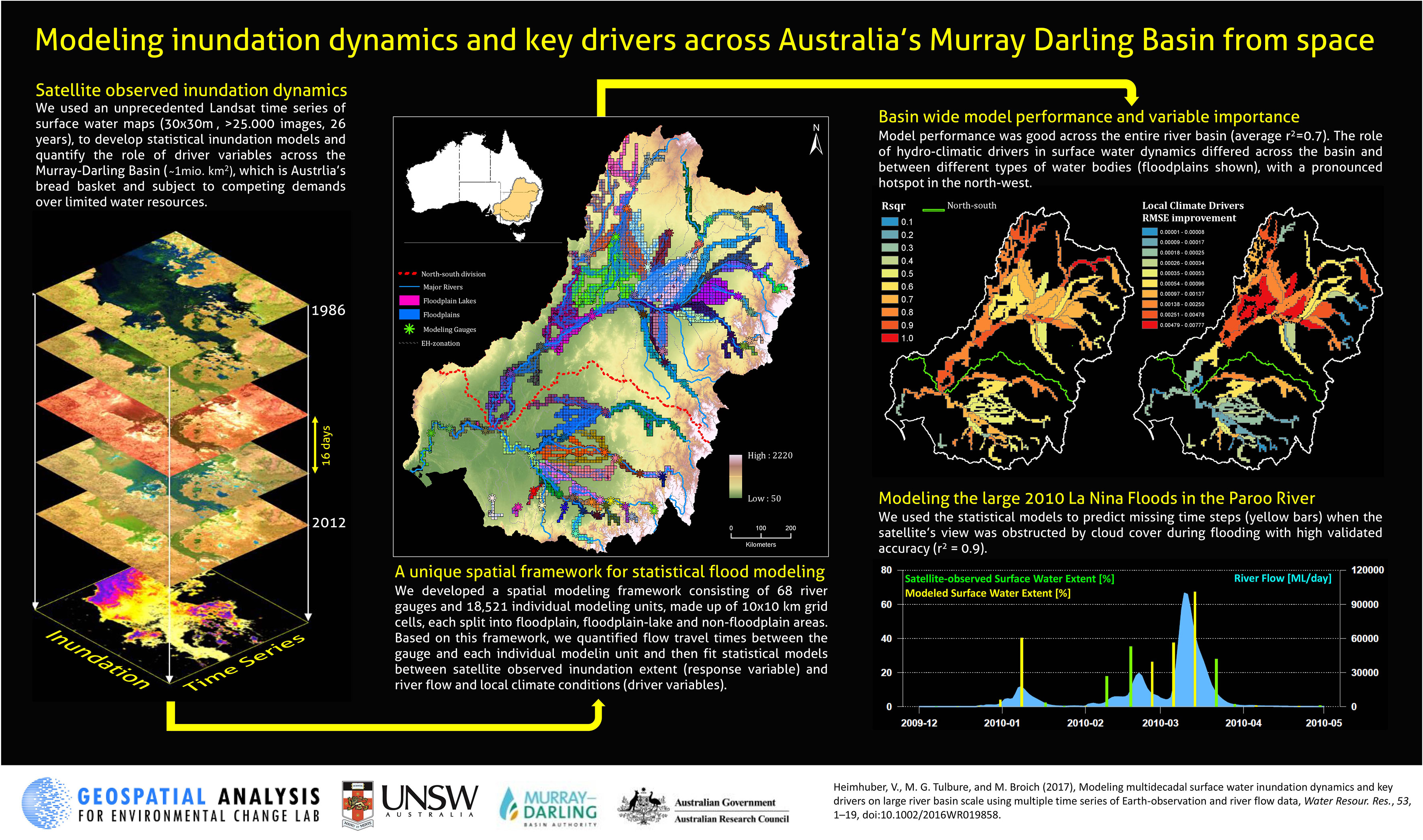
In my PhD at UNSW, I am modelling surface water and inundation dynamics on large river basin scale, using a unique time-series of remotely-sensed surface water maps derived from Landsat imagery (1986 - 2012). This time-series is used in combination with river flow data and spatially explicit time-series of rainfall, evapotranspiration and soil-moisture, to perform a holistic analysis of the spatial and temporal distribution of surface water and its drivers across the Murray-Darling Basin, Australia’s largest and most important river basin. The resulting surface water models provide new insights into hydrological surface processes on sub-continental scale such as the retention and drying behaviour of large floodplains, the propagation of floods over large areas and the role of local rainfall, evapotranspiration and soil moisture for surface water dynamics. At the moment I am incorporating MODIS data into the modeling framework to improve the models' ability to catpure rapid changes in flooding extent.
In the first year of my PhD, I developed a new approach for modeling flooding dynamics across large river basins by combining a variety of satellite and in-situ data sets. The framework is highly-automated and easily applicable to other large river basins across the world such as the Amazon or Congo river basin. Details of the approach are given in the corresponding publication in Hydrology and Earth System Sciences.
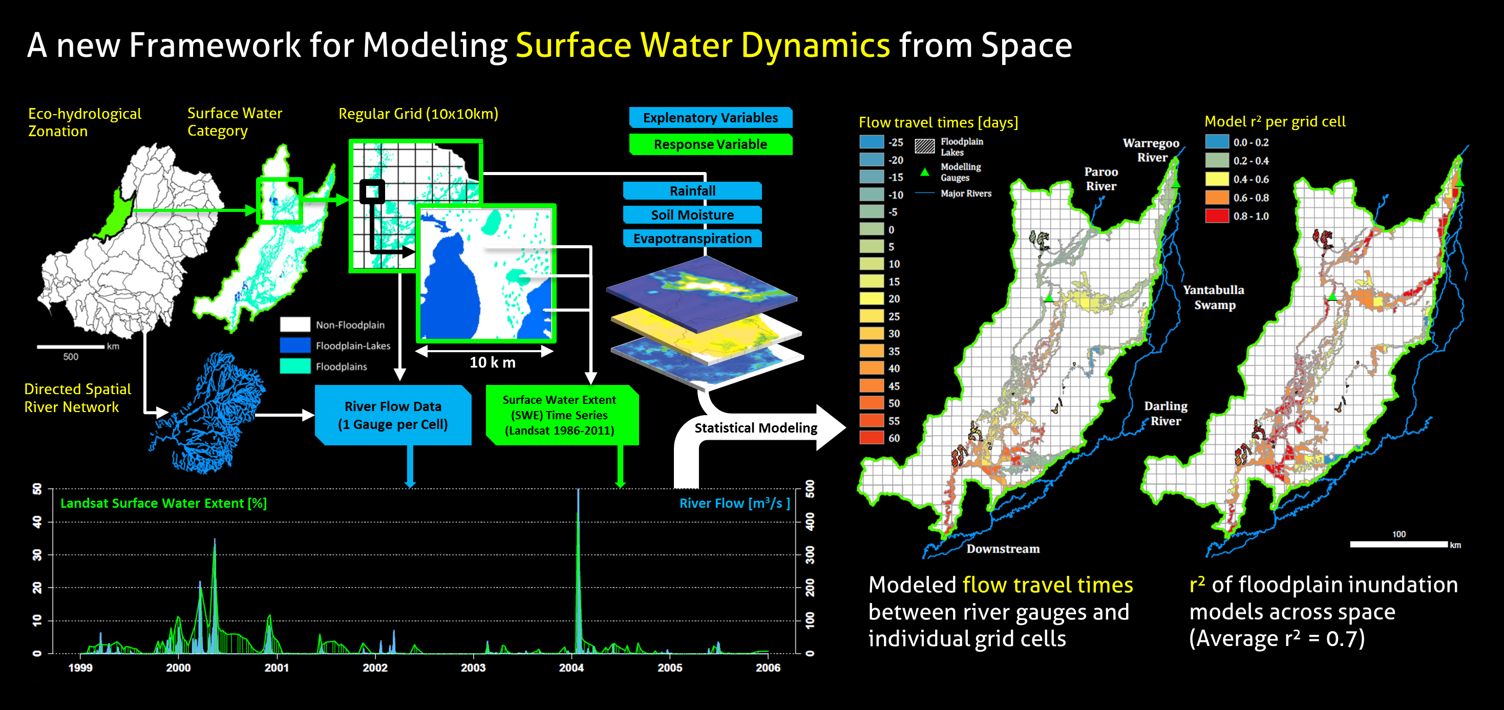
In my second year, I added additional capabilities to the above-mentioned modeling approach and applied the new framework to model flooding dynamics and the role of hydrological key drivers in these dynamics across the entire Murray-Darling Basin, Australia's largest developed river system. The novel statistical modeling approach allowed us to accurately model the relationship between river flow and inundation extent across all major river and floodplain systems in the basin and revealed that in addition to river flow, local climate conditions influence the long-term dynamics of surface water particularly in the extended and unregulated floodplain systems in the northwest of the basin. Details of this modeling application are given in the corresponding publication in Water Resources Research.
PREVIOUS WORK
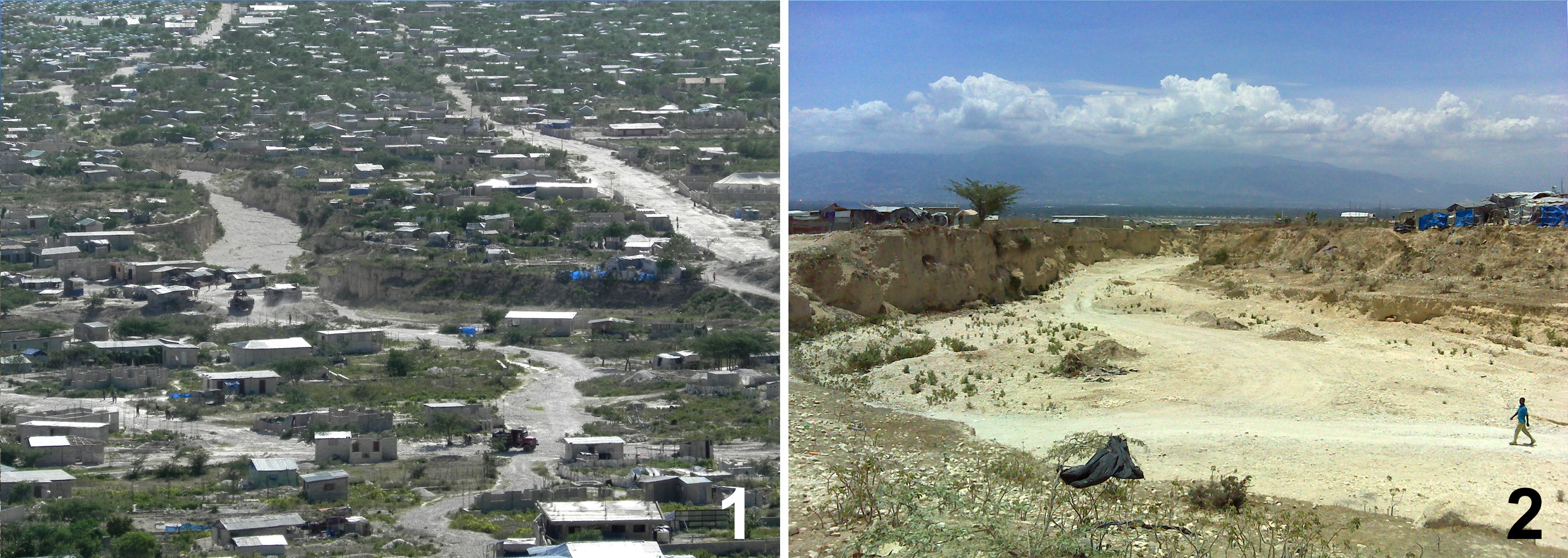
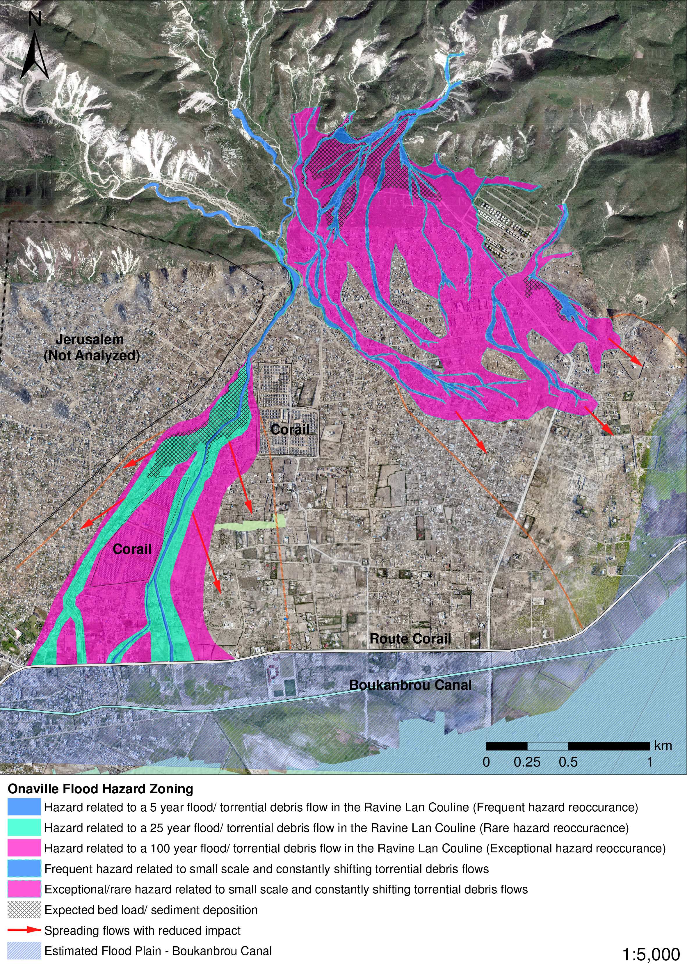
My Master's thesis was part of the interdisciplinary research project "Urban Strategies for Onaville" at Technical University of Munich. In this study, I used GIS-based hydrologic and hydraulic modelling for estimating the flood hazard of the informal settlement Onaville (image below), which is a fairly new and rapidly growing informal settlement in Haiti that is exposed to dangerous flash-flood events.
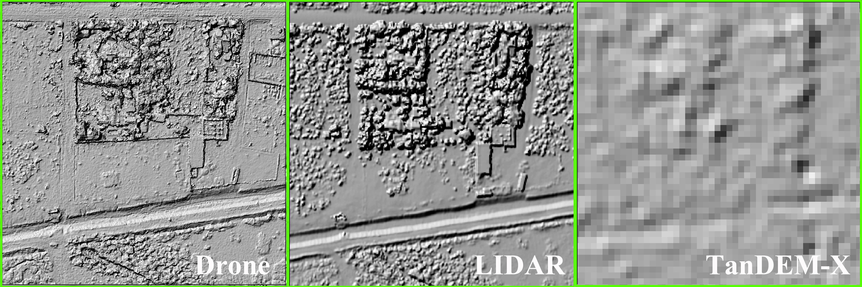
Due to the limited data availability, I used a combination of state-of-the-art remote sensing-based digital elevation models to recreate the geometry of the river channel and the floodplains which is essential for modelling flood runoffs accurately. These data comprised a 12 m spatial resolution DEM provided by the TanDEM-X satellite mission of the German Aerospace Center (DLR), a 30 cm spatial resolution DEM created with mapping drones provided by Drone Adventures and a 1 m spatial resolution LiDAR DEM provided by the World Bank.
The hydraulic modeling software HEC-RAS was used to perform one-dimensional, unsteady-flow simulations of the design floods in the Ravine Lan Couline, which is the major drainage channel of the area and poses the larges flood related risk.
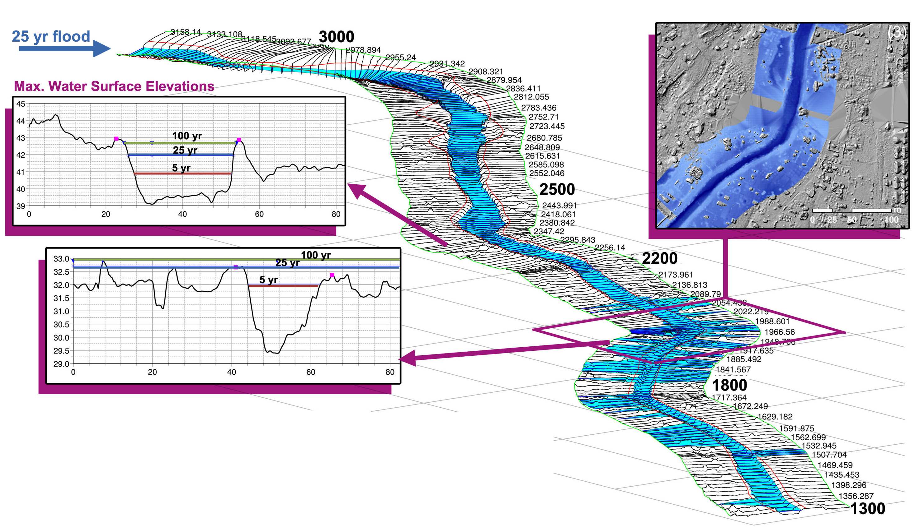
The flow simulations revealed that large areas of the Onaville settlement are currently exposed to flood hazard. The results of the hydrologic and hydraulic modeling were incorporated into a flood hazard map which formed the basis for establishing a functioning flood risk management in Onaville.
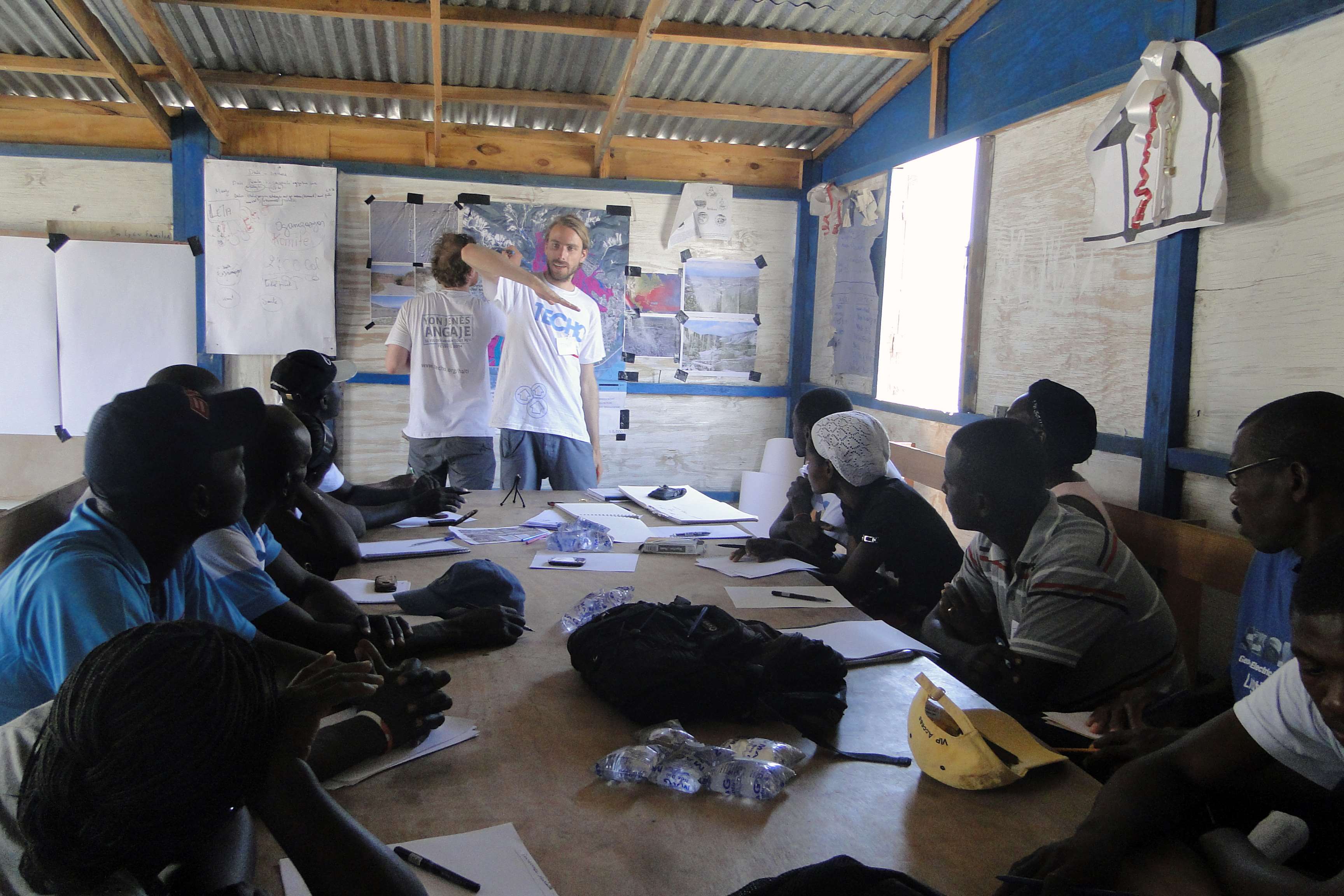
Together with the NGO TECHO and local residents, we established a basic flood risk management for Onaville which comprised an awareness raising campaign, a flood contingency plan and the establishment of a network of flood risk representatives within the residents of Onaville.
Scholarships:
- 2017 Winner of School of BEES (UNSW) 3 Minute Thesis Competition (300AUD) Best 3-minute science talk during School of BEES postgraduate research forum
- E&ERC (UNSW) Outreach and Communication in Evolution and Ecology Award 2016 (200AUD) Award for outstanding achievement in communicating research to the broader community through popular media and outreach activity
- Winner of the MSSANZ best student poster prize at OzEWEX2016 (500AUD) The poster can be seen here and here an interview about my research following the award.
- Winner of the UNSW Science Postgraduate Research Competition 2016 (5000AUD research & travel funding). See the video of my presentation here.
- The Outstanding Ecosystem Science Presentation 2016 (200AUD) (Best presentation in ecosystem science at the Postgraduate Research Forum, UNSW)
- Postgraduate Research Student Scholarship (PRSS) (3000AUD) UNSW scholarship to present my PhD research at the 48th Annual American Geophysical Union Fall Meeting, 14-18 December 2015, San-Francisco, USA
- University International Postgraduate Award - UIPA (+8.000 p.a. Top-up) - Full-cost scholarship for international PhD candidates (University of New South Wales (UNSW), Sydney, Australia)
- Heinz Peter Scholz Award 2014 - (3000 Euro) Award for special achievements in the Master’s program of Environmental Engineering (Technical University of Munich, Munich, Germany)
- ESRI Young Scholars Award 2014 - The ESRI Young Scholars program recognizes exemplary work of students majoring in geospatial science at international universities and invites awardees to present their research at the ESRI International User Conference (ESRI, California, USA) [Site]
- Scholarship for Research Activities in Development Countries - Travel Scholarship for thesis related fieldwork in Haiti (Technical University of Munich)
- PROMOS Scholarship - Scholarship for exchange semester at Stellenbosch University, South Africa (German Academic Exchange Service (DAAD) and Technical University of Munich)
Publications:
- Heimhuber V, Tulbure MG, Broich, M (2018) Addressing spatio-temporal resolution constraints in Landsat and MODIS based mapping of large-scale floodplain inundation dynamics. Remote Sensing of Environment 211:307-320. https://doi.org/10.1016/j.rse.2018.04.016 [Download]
- Heimhuber, V., M. G. Tulbure, and M. Broich (2017), Modeling multidecadal surface water inundation dynamics and key drivers on large river basin scale using multiple time series of Earth-observation and river flow data, Water Resour. Res., 53, 1–19, doi:10.1002/2016WR019858. [Download]
- Heimhuber, V., M.G. Tulbure and M. Broich. (2016). Modeling 25 years of spatio-temporal surface water and inundation dynamics on large river basin scale using time series of Earth observation data. Hydrology and Earth System Sciences. 20: 2227-2250. [Download]
- Heimhuber, V.; Hannemann, J.-C.; Rieger, W. (2015) Flood Risk Management in Remote and Impoverished Areas- A Case Study of Onaville, Haiti. Water, 7, 3832-3860. [Download]
- Heimhuber, V.; Rieger, W. GIS-Based Flood Risk Analysis for Onaville, Canaan-Haiti. gis.Science (2015), 2, 71-82
Conference posters and talks:
- Heimhuber, V., M.G. Tulbure and M. Broich." A new method for quantifying and modeling large-scale surface water inundation dynamics and key drivers using multiple time series of Earth-observation and river flow data. A case study for Australia’s Murray-Darling Basin" Presentation at The General Assembly 2017 of the European Geosciences Union (EGU), 24–28 April 2017, Vienna, Austria.
- Heimhuber, V., M.G. Tulbure and M. Broich." Modeling multi-decadal surface water inundation dynamics and key drivers across the Murray-Darling Basin, Australia, using multiple time series of Earth-observation and river flow data" Poster presentation at the 3rd OzEWEX national workshop, Canberra, ACT, Australia, 14-15 Dec 2016
- Heimhuber, V., M.G. Tulbure and M. Broich. "Modeling surface water dynamics on large river basin scale from space - A case study for Australia's Murray Darling Basin" Poster presentation at the 48th Annual American Geophysical Union Fall Meeting, 14-18 December 2015, San-Francisco, USA.
- Heimhuber, V.; Rieger, W. “GIS-Based Flood Risk Analysis for Onaville, Canaan-Haiti”. Poster presentation at the 2014 ESRI International User Conference, 14-18 July 2014, San-Diego, USA.
Our Team
-

Associate Professor Mirela G. Tulbure
I am an Associate Professor with the Center for Geospatial Analytics.
-

PhD student Mollie Gaines
I am a PhD student with the Center for Geospatial Analytics at North Carolina State University.
-
PhD student Vinicius Perin
Hey all ! I am a PhD student at the Center for Geospatial Analytics at North Carolina State University.