Our new paper on spatiotemporal patterns and effects of climate and land use on surface water extent dynamics in a dryland region with three decades of Landsat satellite data
is out in the Science of The Total Environment: https://www.sciencedirect.com/science/article/pii/S0048969718347466
We made the surface water and flooding dynamics data set based on seasonally continuous Landsat data (1986-2011) freely available on Zenodo:
https://doi.org/10.5281/zenodo.2438110
Animations of the data set per season, per month, and per year are also available on Zenodo: https://doi.org/10.5281/zenodo.2438110
Summary:
Quantifying spatiotemporal distribution of surface water and flooding dynamics and their drivers of change is critical but challenging dur to a lack of spatially explicit and temporally dynamic empirical data of both surface water and its drivers of change at large spatial scales.
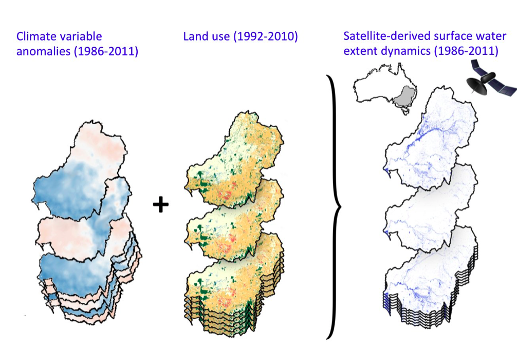
We focused on one of the largest dryland basins in the world, Australia's Murray-Darling Basin (MDB), recently identified as a global hotspot of water decline and used a new remotely sensed time-series of surface water extent dynamics (SWD) data
We quantified spatiotemporal patterns in surface water across the entire MDB and catchments and to assess natural and anthropogenic drivers of SWD, including climate and historical land use change.
We show high intra- and inter-annual dynamics in surface water with a rapid loss during the Millennium Drought, the worst, decade-long drought in SE Australia.
We show strong regional and catchment differences in SWD, with the northern basin showing high variability compared to the southern basin which shows a steady decline in surface water.
Linear mixed effect models including climate and land-use change variables explained up to 70% variability in SWD with climate being more important in catchments of the northwestern MDB, whereas land-use was important primarily in the central MDB.
Increase in fraction of dryland agriculture in a catchment and maximum temperature was negatively related to SWD, whereas precipitation and soil moisture were positively related to SWD.
The fact that land-use change was an important explanatory variable of SWD in addition to climate is a significant result as land-use can be managed more effectively whereas climate-mitigation actions can be intractable, with global change scenarios predicting drier conditions for the area followed by a further reduction in surface water availability.
Citation: Tulbure, M.G. and M. Broich (2018). Spatiotemporal patterns and effects of climate and land use on surface water extent dynamics in a dryland region with three decades of Landsat satellite data. Science of the Total Environment. https://www.sciencedirect.com/science/article/pii/S0048969718347466