Environmental Flows: Managing Water in the Murray Darling Basin
Originally produced for NASA's Landsat Science News Service by Laura Rocchio. See full article here.
Dr. Mark Broich, a researcher at the Geospatial Analysis for Environmental Change Lab (GAEC) the University of New South Wales gave a talk at #AGU16 showing how seasonal flooding impacts riparian vegetation in Australia’s Murray Darling Basin. We spoke with Dr. Broich about his work:
Presentation Title
Using remote sensing time series to model the impact of changing flooding regimes on riparian vegetation in Australia’s most important river basin
What are the major findings of this research?
This is the first study to quantify the relationship of riparian vegetation to flooding dynamics and climate using the seasonally continuous Landsat archive over 25 years at sub-continental scale.
The work used internally consistent and locally relevant data and modeling across the entire Murray-Darling Basin (MDB), Australia’s semi-arid breadbasket. Importantly, both the flooding and vegetation dynamics were quantified using the same data set (i.e., the seasonally continuous Landsat archive).
The amount of rainfall had a positive correlation to vegetation greenness as measured by the enhanced vegetation index (EVI). Flooding in the previous and previous two seasons triggered an increase in greenness in floodplain areas. The relationship quantified changed over the 25 years under investigation, with marked breakpoints at the start of the Millennium Drought (caused by a sequence of El Nino events).
What are the implications of your findings; why are they of interest to land and water management decision makers?
The Murray Darling Basin Authority (MDBA) is Australia’s federal agency tasked with managing water resources of the MDB. The MDB is one of the largest (>1 million km2) and driest semi-arid basins in the world with intensifying conflicts over scarce resources, especially after it has suffered shrinkages in water resources during the Millennium Drought.
The negative impact of the Millennium Drought on water resources has led to the investment of billions of dollars into buying back water and releasing this water into the systems as ‘environmental flows’. Environmental flows are controlled releases of water from storage to mimic natural flooding dynamics with the aim of restoring and maintaining the health of riparian vegetation and ecosystems.
To this end, a quantitative understanding of the relationship between riparian vegetation and flooding dynamics, while controlling for the influence of local rainfall, and how and why this relationship changes over time as provided by our research is paramount to the work of MDBA.
What insight did you gain from Landsat that would have been impossible to glean otherwise?
Pervious studies researching vegetation response to flooding in riparian areas focused on small areas or short time intervals. Yet long time series at relevant spatial scales are needed to quantify the relationship between vegetation response and flooding. This is even more important in semi-arid areas such as the MDB, where inter-annual rainfall and flooding variability are high.
The MDB is a globally relevant basin equal in size to the U.S. 4-corner states. Landsat is the only satellite data archive that allows the quantification of vegetation and flooding dynamics relationships across such a large area. Key features unique to the Landsat archive that are paramount for our work include the archive’s temporal depth and detail provided by over a quarter century of systematically acquired time series of imagery at management-relevant spatial resolution.
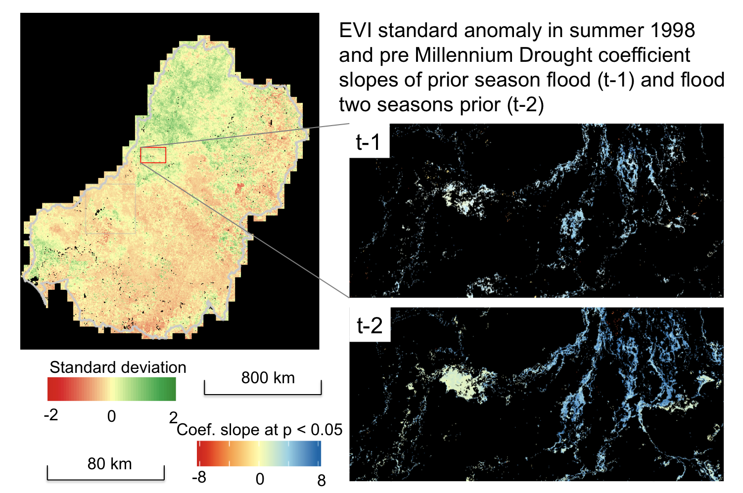
Left: A map showing vegetation response (using the Enhanced Vegetation Index) across Australia’s Murray Darling Basin in summer 1998. Right: Maps showing quantified (pre-drought) relationship of vegetation response with flooding in prior season and two seasons prior for an example sub-region of the MDB”.
Co-authors:
Mirela G Tulbure
University of New South Wales
Jan Verbesselt
Wageningen University
Qinchuan Xin
Sun Yat-Sen University
Related Reading:
+ Thirsting for Equitable Water Distribution, Australia Turns to Landsat
References:
Tulbure, M. G., M. Broich, S.V. Stehman, A. Kommareddy. (2016). Surface water extent dynamics from three decades of seasonally continuous Landsat time series at sub continental scale in a semi-arid region. Remote Sensing of Environment.
Broich M., A. Huete, M. Paget, X. Ma, R. Devadas, N. Restrepo-Coupe, K. Davies, A. Held. (2015). A spatially explicit Land Surface Phenology data product for science, monitoring and natural resources management applications. Environmental Modelling & Software.
Broich M., A. Huete, M.G. Tulbure, X. Ma, Q. Xin, M. Paget, N. Restrepo-Coupe, K. Davies, R. Devadas, A. Held. (2014) Land surface phenological response to decadal climate variability across Australia using satellite remote sensing. Biogeosciences Special Issue on Climate Extremes and Biogeochemical Cycles in the Terrestrial Biosphere: Impacts and Feedbacks Across Scales.
M.G. Tulbure and M. Broich. (2013). Spatiotemporal dynamic of surface water bodies using Landsat time-series data from 1999 to 2011. ISPRS Journal of Photogrammetry and Remote Sensing.