Vinicius Perin
PhD student
Office address:Jordan Hall
2800 Faucette Boulevard, Raleigh, NC 27607
Field of Research:Remote sensing, Surface Hydrology, Geospatial modeling
Biography:
Hey all ! I am a PhD student at the Center for Geospatial Analytics at North Carolina State University. I am currently working with remote sensing imagery to assess surface water dynamics. Check out my website for more information about my work.
Research
Quantifying on-farm reservoirs’ impacts on surface hydrology using a multi-sensor approach
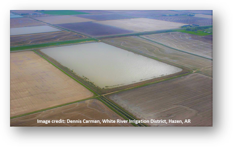
Fresh water stored by on-farm reservoirs (OFRs) is a fundamental component of surface hydrology and is critical for meeting global irrigation needs. Farmers use OFRs to store water during the wet season for crop irrigation during the dry season. There are more than 2.6 million OFRs in the US alone, and many of these OFRs were constructed during the last 40 years. Despite their importance for irrigating crops, OFRs can contribute to downstream water stress by decreasing stream discharge and peak flow in the watersheds where they are built, thereby exacerbating water stress intensified by climate change and population growth. However, modeling the impact of OFRs on surface hydrology remains a challenge because they are so abundant and have frequent fluctuations in surface area and water volume. Prior to the recent availability of satellite data, widespread monitoring of OFRs’ surface area and water volume across space and time was impossible due to temporal latency of satellite observations. The goal of this project, therefore, is to harness a multi-sensor satellite imagery approach to reduce observation latency and improve surface hydrology modeling, with the aim of supporting more efficient management of OFRs and mitigation of their downstream impacts. Our objectives are:
- Objective 1:
Develop a multi-sensor imagery approach to reduce latency and obtain sub-weekly OFRs surface area and volume change.
A novel method based on the Kalman filter will be used to harmonize data from multiple optical sensors and to provide sub-weekly OFRs surface area change, which will be converted to volume change using area-elevation equations.
The Kalman filter is a recursive inference algorithm that is not sensor-dependent and considers uncertainty in both the observations and resulting estimates, which are advantages over other algorithms.•
- Objective 2:
Input sub-weekly OFRs volume change into the Soil Water and Assessment Tool (SWAT) model to estimate OFRs’ impact on surface hydrology.
Volume change is pivotal to estimating OFRs’ impact on surface hydrology; however, this information is rarely available for individual OFRs. The Kalman filter method will enable us to estimate volume change for individual OFRs.
Few, if any, studies have coupled a multi-sensor approach with hydrological modeling to assess the OFRs’ impacts.
Publications:
- Perin, V., Tulbure, M.G., Gaines, M.D., Reba, M.L., Yaeger, M.A., 2021. On-farm reservoir monitoring using Landsat inundation datasets. Agric. Water Manag. 246, 106694. https://doi.org/10.1016/j.agwat.2020.106694
- Yoshizumi A, Coffer MM, Collins EL, Gaines MD, Gao X, Jones K, McGregor IR, McQuillan KA, Perin V, Tomkins LM, Worm T. A Review of Geospatial Content in IEEE Visualization Publications. 2020 Sep 7. arXiv preprint arXiv:2009.03390
- Perin, V, Santos, EA, Lollato, R, Ruiz‐Diaz, D, Kluitenberg, GJ. Impacts of ammonia volatilization from broadcast urea on winter wheat production. Agronomy Journal. 2020; 1– 15. https://doi.org/10.1002/agj2.20371
- Lollato, RP, Bavia, GP, Perin, V, et al. Climate‐risk assessment for winter wheat using long‐term weather data. Agronomy Journal. 2020; 112: 2132– 2151.https://doi.org/10.1002/agj2.20168
- Perin, V., Sentelhas, P.C., Dias, H.B., Santos, E.A., 2019. Sugarcane irrigation potential in Northwestern São Paulo, Brazil, by integrating Agrometeorological and GIS tools. Agric. Water Manag. 220. https://doi.org/10.1016/j.agwat.2019.04.012
Our Team
-

Associate Professor Mirela G. Tulbure
I am an Associate Professor with the Center for Geospatial Analytics.
-
PhD student Mollie Gaines
I am a PhD student with the Center for Geospatial Analytics at North Carolina State University.
-
PhD student Vinicius Perin
Hey all ! I am a PhD student at the Center for Geospatial Analytics at North Carolina State University.