
Mirela G. Tulbure
Associate Professor
Email: mtulbure@ncsu.eduOffice address:
Jordan Hall 5227, North Carolina State University
Raleigh, NC 27695 USA
Flooding, Remote Sensing, Surface Hydrology, Geospatial Analytics, Dynamic Networks
Biography:
I am an Associate Professor with the Center for Geospatial Analytics at North Carolina State University (NCSU).
I relocated to NCSU in Aug 2019 from the University of New South Wales (UNSW) in Sydney, Australia, where I had a faculty position as an Australian Research Council DECRA fellow and a senior lecturer. Since joining UNSW in 2012, I have built the Geospatial Analysis for Environmental Change Lab. Broadly, in my research I use time-series of satellite and other geospatial data to develop algorithms for quantifying flooding and surface water extent, vegetation and landscape connectivity dynamics, and their drivers of change (climate variability, climate and land-use change). I use an interdisciplinary, top-down data-driven approach using terabytes of satellite and other spatial data and cloud computing, network analysis using graphs, and spatial analysis to quantify space-time patterns in flooding, surface water, vegetation and landscape connectivity dynamics. Results of my work can underpin water policy and management in areas with competing water demands and conservation decisions. In my prior work I have translated my research findings to government organizations, which have attested the importance of my work for policy and management decisions.
Research
CURRENT WORK
I am currently working on mapping and quantifying flooding and surface water extent dynamics using decades of satellite time series.
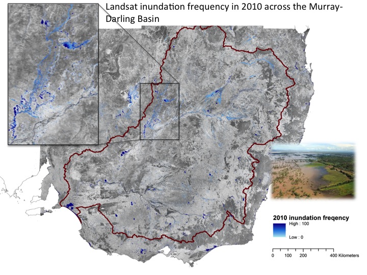
Prior projects focused on quantifying surface water and flooding extent dynamics at sub-continental scale (e.g., the Murray-Darling River Basin (MDB), one of the largest dryland basins in the world), assessing drivers of flooding dynamics, quantifying spactiotemporal connectivity of surface water habitats using network analysis, quantifying vegetation response to flooding, and characterising vegetation health using airborne lidar and hyperspectral and satellite time series data. More specifically, I have developed the first spatially detailed and seasonally continuous surface water and flooding extent dynamics quantification at sub-continental scale at then the highest available temporal (every 16-days) and unprecedented spatial resolution (30m) by processing ~5TB (25,000 compressed images) of Landsat satellite data over three decades (Tulbure et al 2016). Highlights of this work were featured by NASA Landsat Science, chosen as NASA’s image of the day in July 2016, in Australia by OzEWEX and featured on the ARC website as part of research highlights. This work allowed me to quantify the basin’s dramatically changing expanse of surface water and showed how the Millennium Drought and following La Niña deluges impacted surface water throughout the MDB. For this work, I was awarded the New South Wales Young Tall Poppy Science Award for outstanding research by an early career researcher from the Australian Institute of Policy and Science. I then showed that besides extreme climate variability, land-use is as important in driving surface water extent dynamics, particularly at local scales, suggesting that measures that we can implement locally based on decision on how we use our land can have a significant impact on water quantity dynamics (Tulbure and Broich, 2019). In current work, I used NASA’s Harmonized Landsat/Sentinel-2 data product and showed that the higher frequency of several sensors combined are critical in capturing ephemeral phenomena such as ephemeral flooding in drylands (Tulbure et al., AGU 2020 talk).
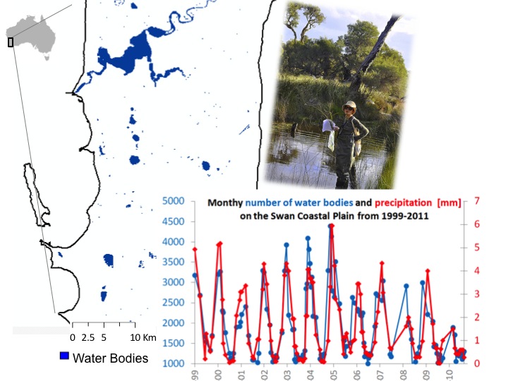
Other prior work has focused on the southwest of Western Australia (one of the 25 global biodiversity hotspots in the world, see Tulbure and Broich (2013) and Tulbure et al. (2014)), the U.S. Great Lakes and Northern Great Plains and the Danube River Basin.
FORMER WORK
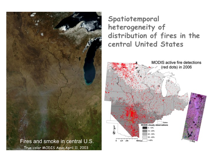
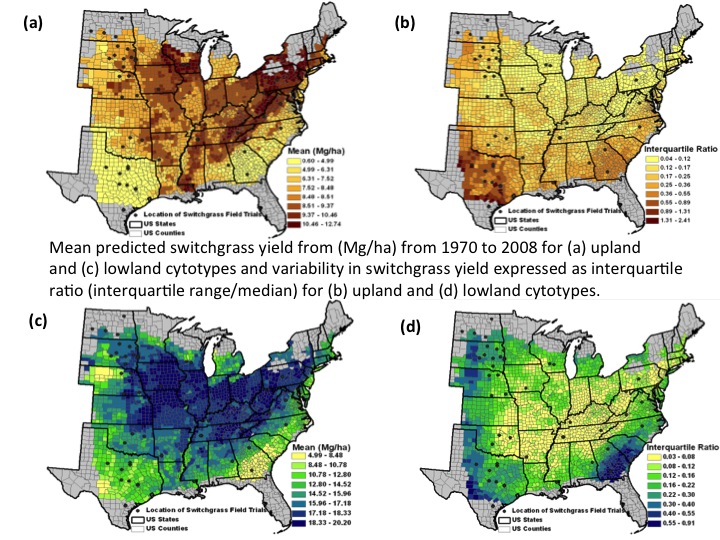
1. Geospatial Analysis of Agroecosystems: Together with Professor Mike Wimberly I utilized large area remote sensing and spatial statistics to understand the environmental impacts of associated land use and land cover change and effects of increasing food and energy needs on cropping patterns in the U.S.. As part of this project, my research has assessed the climatic and genetic controls of yields of switchgrass, a model bioenergy species (Tulbure et al 2012a, featured on-line on Renewable Energy Global Innovations), and projected changes in yield under future climate scenarios (Tulbure et al 2012b). This research also showed the prevalence of prescribed burning across the U.S., resulting in increased CO2 and greenhouse gas emissions (Tulbure et al 2011).
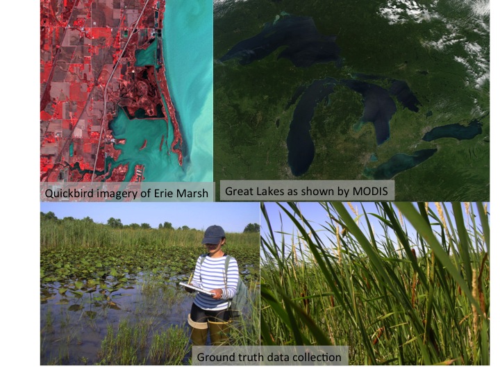
2. Great Lakes Environmental Indicators Project: This research was part of a large multi-institutional project to develop indicators of Great Lakes wetlands condition based on different groups of biota. As part of this project and together with Professor Carol Johnston, I have looked at what factors influence plant invasion in wetlands (Tulbure et al 2008, Tulbure and Johnston 2010) and how satellite images can be used for mapping wetland vegetation and invasive species (Ghioca, Johnston and Tulbure 2010). I have also teamed up with scientists at the Smithsonian Environmental Research Centre to understand factors that impart invasiveness in plants (Tulbure et al. 2012).
Teaching
Mirela’s teaching interests are in increasing student’s ability to use satellite data to answer pressing environmental and sustainability questions and extract space time value added information relevant for ecological applications.
My current teaching at NCSU entails:
GIS 712 Environmental Earth Observation and Remote Sensing - I have developed and taught this course for the first time in autumn 2020 using open source using open source software including Python, Jupyter notebooks, git, and QGIS. A syllabus is available here.
ES 400 Analysis of Environmental Issues, a capston course.
Prior teaching at the University of New South Wales I taught:
Advanced Techniques in Remote Sensing (GEOS3811)
Data Analysis for Life and Earth Science (BEES2041)
I also lectured in Ground and Surface Water (GEOS2291)
Scholarships:
- 2020 SESYNC workshop (costs covered by SESYNC, 25 applicants selected out of 60+): “People, Land, & Ecosystems: Leveraging NEON for Socio-Environmental Synthesis” Annapolis, MD
- 2020 Distinguished contribution/manuscript highlight for Tulbure and Broich (2019) by Ladies of Landsat Manuscript Monday series [Manuscript Monday is a weekly series highlighting cutting-edge research impacting the field of remote sensing]
- 2020 Land Editor’s Choice Article for Zeller, Lewison, Fletcher, Tulbure, and Jennings
- 2019 Chancellor's Faculty Excellence Program, Geospatial Analytics Faculty cluster, NCSU
- 2017 Remote Sensing of Environment - Outstanding Contribution in Reviewing
- 2015 NSW Young Tall Poppy Science Award from the Australian Institute of Policy and Science in recognition of outstanding research/academic achievement as well as excellence in communication and community engagement to promote an understanding of science
- 2014 Australian Research Council Discovery Early Career Researcher Award
- 2014 Open Science for Synthesis fellowship at the National Centre for Ecological Analysis and Synthesis (University of California)
- 2014 Shortlisted for L’Oreal Australia and New Zealand for Women in Science Fellowship
- 2013 China Australia Young researcher award to travel to China to establish collaborations with Chinese partners and represent Australia (among 16 early to mid-career awardees across Australia’s Group of Eight Universities, two awardees from University of NSW)
- 2012 ACEAS workshop invitation: Local to national – the capacity for increasing the spatial scale of monitoring
- 2007 Society of Wetland Scientists Research Grant
- 2007 Society of Wetland Scientists North Central Chapter, Travel Award
- 2007 Graduate Research Award (South Dakota State University, SDSU)
- 2006-2007 four Travel Awards (SDSU)
- 2006 Excellence in Teaching Award (SDSU)
- 2005 Joseph Nelson Award, SDSU ($5,000 research funds)
- 2003 Outstanding MSc Student Award, Central European University, Hungary
- 2002 Open Society Foundation Scholarship to undertake MSc Program ($11,600)
- 2002 Best Student of the Faculty Award, Ministry of Education and Research Romania
- 2002 Sarghie Bucovinian Brothers Foundation Award for the best student of the faculty, University of Bucharest
Publications:
Underlined are our lab's PhD students
- Perin, V., Tulbure, M.G., Gaines, M.D., Reba, M.L., Yaeger, M.A. (2021) On-farm reservoir monitoring using Landsat inundation datasets. Agricultural Water Management. 246, 106694 [Download]
- KA Zeller, R Lewsion, RJ Fletcher, MG Tulbure, MK Jennings (2020) Understanding the Importance of Dynamics Landscape Connectivity. Land 9 (303) [Download]
- Heimhuber, V., M.G. Tulbure, M. Broich, Z. Xie, M. Hurriyet. (2019) The role of GRACE total water storage anomalies, streamflow and rainfall in stream salinity trends across Australia’s Murray-Darling Basin during and post the Millennium Drought. International Journal of Applied Earth Observations and Geoinformation [Download]
- Tulbure, M.G., M. Broich. (2019) Spatiotemporal patterns and effects of climate and land use on surface water extent dynamics in a dryland region with three decades of Landsat satellite data. Science of the Total Environment 658, 1574-1585 [Download]
- Shendryk, I., M. Broich, M.G. Tulbure. (2018) Multi-sensor airborne and satellite data for upscaling tree number information in a structurally complex eucalypt forest. International Journal of Applied Earth Observation and Geoinformation. 73:397-406 https://doi.org/10.1016/j.jag.2018.07.011. [Download]
- Broich, M,. Tulbure, MG,. Verbesselt, J,. Xin Q,. Wearne, J,. (2018) Quantifying Australia's dryland vegetation to flooding and drought at sub-continental scale. Remote Sensing of Environment. 211:60-78. https://doi.org/10.1016/j.rse.2018.04.032 [Download]
- Heimhuber V, Tulbure MG, Broich, M (2018) Addressing spatio-temporal resolution constraints in Landsat and MODIS based mapping of large-scale floodplain inundation dynamics. Remote Sensing of Environment. 211:307-320. https://doi.org/10.1016/j.rse.2018.04.016 [Download]
- R Bishop-Taylor, MG Tulbure, M Broich (2018) Evaluating static and dynamic landscape connectivity modelling using a 25-year remote sensing time series. Landscape Ecology. 33:625–640 https://doi.org/10.1007/s10980-018-0624-1 [Download]
- Bishop-Taylor, R., M.G. Tulbure, M. Broich. (2017) Impact of hydroclimatic variability on regional-scale landscape connectivity across a dynamic dryland region. Ecological Indicators. https://doi.org/10.1016/j.ecolind.2017.07.029 [Download]
- Bishop-Taylor, R., Tulbure, M. G. and Broich, M. (2017), Surface-water dynamics and land use influence landscape connectivity across a major dryland region. Ecol Appl. Accepted Author Manuscript. doi:10.1002/eap.1507 [Download]
- Heimhuber, V., Tulbure, M.G., and Broich, M. (2017) Modeling multidecadal surface water inundation dynamics and key drivers on large river basin scale using multiple time series of Earth observation and river flow data. Water Resources Research. Accepted Author Manuscript. doi: 10.1002/2016WR019858 [Download]
- Shendryk, I., M. Broich, M.G. Tulbure, A. McGrath, D. Keith and S. V. Alexandrov (2016). Mapping individual tree health using full-waveform airborne laser scans and imaging spectroscopy: A case study for a floodplain eucalypt forest. Remote Sensing of Environment 187: 202-217. [Download]
- Malone, S. L., M.G. Tulbure, A. J. Pérez-Luque, T. J. Assal, L. L. Bremer, D. P. Drucker, V. Hillis, S. Varela, and M. L. Goulden. 2016. Drought resistance across California ecosystems: evaluating changes in carbon dynamics using satellite imagery. Ecosphere 7(11):e01561. 10.1002/ecs2.1561 [Download]
- Heimhuber, V., M.G. Tulbure and M. Broich. (2016). Modeling 25 years of spatio-temporal surface water and inundation dynamics on large river basin scale using time series of Earth observation data. Hydrology and Earth System Sciences. 20: 2227-2250. [Download]
- Tulbure M.G., M. Broich, S.V. Stehman & A. Kommareddy. (2016). Surface water extent dynamics from three decades of seasonally continuous Landsat time series at subcontinental scale in a semi-arid region. Remote Sensing of Environment 178: 142–157. [Download]
- Shendryk, I., M. Broich, M.G. Tulbure & S.V. Alexandrov. (2016). Bottom-up delineation of individual trees from full-waveform laser scans in a structurally complex eucalypt forest. Remote Sensing of Environment 173: 69–83 . [Download]
- Bishop-Taylor, R., M.G. Tulbure & M. Broich. (2015) Surface water network structure, landscape resistance to movement and flooding vital for maintaining ecological connectivity across Australia’s largest river basin. Landscape Ecology. doi: 10.1007/s10980-015-0230-4. [Download]
- Broich M., Huete A., M. Paget, X. Ma, Tulbure M.G., N. Restrepo-Coupe, B. Evans, J. Beringer, R. Devadas, K. Davies, & A. Held. (2015) A spatially explicit land surface data product for science, monitoring and natural resources management applications. Environmental Modelling and Software. 64: 191-204. [Download]
- Dafforn, K.A., E.L. Johnston, A. Ferguson, C. Humphrey, W. Monk, S.J. Nichols, S.L. Simpson, M.G. Tulbure & D.J. Baird. (2015) Data opportunities and challenges for assessing multiple stressors across scales in aquatic ecosystems. Marine and Freshwater Research. [Download]
- Tulbure, M.G., S. Kininmonth & M. Broich. (2014) Spatiotemporal dynamics of surface water networks across a global biodiversity hotspot – implications for conservation. Environmental Research Letters. 9: 114012. Featured in online media: Environmental Research Web; EurekAlert [Download]
- Broich M., Huete A., Tulbure M.G., X. Ma, Q. Xin, M. Paget, N. Restrepo-Coupe, K. Davies, R. Devadas & A. Held. (2014) Land surface phenological response to decadal climate variability across Australia using satellite remote sensing. Biogeosciences. 11 (5), 7685-7719. [Download]
- Tulbure, M.G. & M. Broich. (2013) Spatiotemporal dynamic of surface water bodies using Landsat time-series data from 1999 to 2011. ISPRS Journal of Photogrammetry& Remote Sensing. 79:44-52. [Download] For an animation of the surface water dynamics click [here].
- Tulbure, M.G. & M. Broich. (2013) Data from: Spatiotemporal dynamic of surface water bodies using Landsat time-series data from 1999 to 2011. Dryad Digital Repository. doi:10.5061/dryad.50003 [Download]
- Chintala R., M.C. Wimberly, G.D. Djira, & M.G.Tulbure. (2013) Interannual Variability of Crop Residue Potential in the North Central Region of the United States. Biomass and Bioenergy. 49:231-238. [Download]
- Tulbure, M.G. M.C. Wimberly & V. C. Owens. (2012) Response of switchgrass yields to future climate change. Environmental Research Letters special issue on Biofuels. 7 045903. [Download]
- Tulbure, M.G., D.M. Ghioca, C.A. Johnston & D.F. Whigham. (2012) Ventilation efficiency of nonnative and native Phragmites australis (common reed) in tidal wetlands. Estuaries and Coasts. 35(5): 1353-1359. [Download]
- Tulbure, M.G., M.C. Wimberly, A. Boe, and V. Owens. (2012) Climatic and genetic controls of yields of switchgrass, a model bioenergy species. Agriculture, Ecosystems, and Environment. 146(1): 121-129. Featured on line on Renewable Energy Global Innovations. [Download]
- Tulbure, M.G., M.C. Wimberly, D.P. Roy & G.M. Henebry. (2011) Spatial and temporal heterogeneity of agricultural fires in the central United States in relation to land cover and land use. Landscape Ecology. 26(2): 211-224. [Download]
- Tulbure, M.G. & C.A. Johnston. (2010) Environmental conditions promoting non- native Phragmites australis expansion in Great Lakes coastal wetlands. Wetlands. 30(3): 577- 587. [Download]
- Johnston, C. A., J.B. Zedler, M.G.Tulbure. (2010) Latitudinal Gradient of Floristic Condition among Great Lakes Coastal Wetlands. Journal of Great Lakes Research. 36(4):772-779. [Download]
- Johnson, W.C., B. Werner, G. Guntenspergen, R.Voldseth, B. Millett, D.Naugle, M.G.Tulbure, R. Carroll, J. Tracy & C. Olawsky. (2010). Prairie Wetland Complexes as Functional Units in a Changing Climate. BioScience. 60(2):128-140. [Download]
- Johnston, C. A., J.B. Zedler, M.G.Tulbure, C. B. Frieswyk, B. L. Bedford & L. Vaccaro. (2009) A Unifying Approach for Evaluating the Condition of Wetland Plant Communities and Identifying Related Stressors. 2009. Ecological Applications. 19(7): 1739-1757. [Download]
- Tulbure, M.G., C.A. Johnston & D.L Auger. (2008) Rapid Invasion of a Great Lakes Coastal Wetland by non-native Phragmites australis and Typha. Journal of Great Lakes Research. 33(3): 269-279. [Download]
- Ghioca, D., C. A. Johnston, and M.G.Tulbure. (2008) Assessing the Use of Multiseason QuickBird Imagery for Mapping a Lake Erie Coastal Marsh. Wetlands. 28(4): 1028-1039. [Download]
- Johnston, C. A., B. Bedford, M. Bourdaghs, T. Brown, C. B. Frieswyk, M.G. Tulbure, L. Vaccaro & J. B. Zedler. (2008) Plant species indicators of physical environment in Great Lakes coastal marshes. Journal of Great Lakes Research. 33(3): 106-124. [Download]
- Johnston, C.A., Ghioca D, M.G. Tulbure, B. Bedford, M. Bourdaghs, C. B. Frieswyk, L. Vaccaro & J. B. Zedler. (2008) Partitioning vegetation response to anthropogenic stress to develop multi taxa indicators of wetland condition. Ecological Applications. 18(4): 983-1001. [Download]
Datasets:
Tulbure, M.G. & M. Broich. (2019) Surface water and flooding dynamics data set based on seasonally continuous Landsat data (1986-2011) in a dryland river basin. Zenodo: https://doi.org/10.5281/zenodo.2441784
Tulbure, M.G. & M. Broich. (2019) Surface water and flooding dynamics based on seasonally continuous Landsat data (1986-2011) in a dryland river basin (monthly, seasonally, and yearly animations). Zenodo: https://doi.org/10.5281/zenodo.2438110
Bishop-Taylor, R., Tulbure, M.G. & M. Broich. (2017) Data from: Surface-water dynamics and land use influence landscape connectivity across a major dryland region. Dryad Digital Repository. http://datadryad.org/resource/doi:10.5061/dryad.qf83q
Tulbure, M.G. & M. Broich. (2013) Data from: Spatiotemporal dynamic of surface water bodies using Landsat time series data from 1999 to 2011. Dryad Digital Repository. http://datadryad.org/resource/doi:10.5061/dryad.50003
Our Team
-

Associate Professor Mirela G. Tulbure
I am an Associate Professor with the Center for Geospatial Analytics.
-

PhD student Mollie Gaines
I am a PhD student with the Center for Geospatial Analytics at North Carolina State University.
-
PhD student Vinicius Perin
Hey all ! I am a PhD student at the Center for Geospatial Analytics at North Carolina State University.