
Mark Broich
Postdoctoral research fellow
Email: mark.broich@unsw.edu.auOffice address:
Kensington Campus
Research title: A novel approach for assessing environmental flows using satellite data (Australian Research Council Linkage Grant with the Murray-Darling Basin Authority)Field of Research:
Large area environmental remote sensing, spatial-temporal dynamics and change, forest loss, vegetation dynamics, vegetation response to flooding
Biography:
I am playing a central research role on the Geospatial Analysis for Environmental Change team and had a key role in building the GAEC lab. As an innovative geospatial researcher I have extensive skills in quantitative spatial-temporal analysis and modelling of large datasets using remote sensing, geographic information systems (GIS), machine learning, spatial statistics and high performance computing (HPC). My far reaching international experience includes work in developing nations such as Indonesia and DR Congo. Since joining UNSW as a Postdoctoral Research Fellow, I have been developing remote sensing algorithms quantifying surface water extent dynamics and vegetation response to flooding as part of an Australian Research Council Linage Grant and jointly supervise the lab’s three PhD students.
Research
Current project
1. Australian Research Council Linkage Grant working with Dr Mirela Tulbure: "A novel approach for assessing environmental flows using satellite data". This project will determine how ecosystems respond to environmental flow by linking flooding history with vegetation responses, using remote sensing, climate data layers, spatial statistics, models of environmental flows and ecological theory. Beneficiaries will include water and land managers in Australia.
Former projects
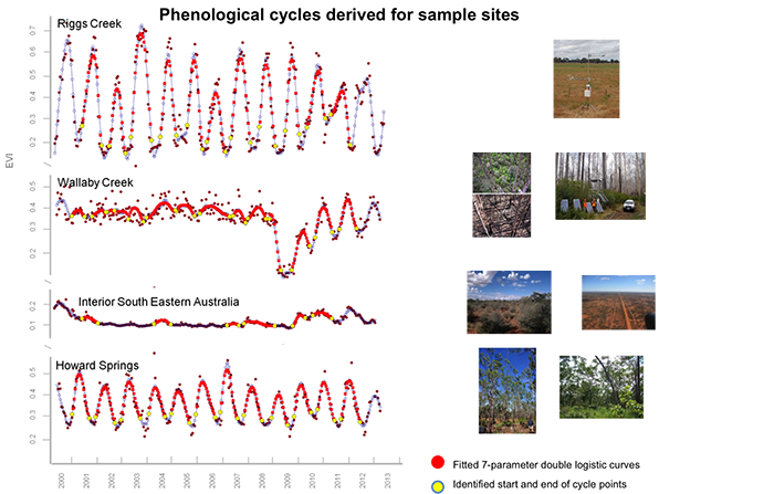
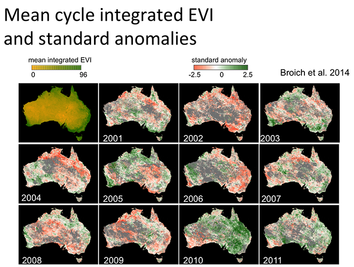
1. AusCover/TERN satellite phenology product for Australia (v1): In contribution to the Terrestrial Ecosystems Research Initiative’s AusCover remotes sensing facility, Mark developed Australia’s first remote sensing-based phenological characterization product (Broich et al. 2014 & 2015; [link to data]) in collaboration with the University of Technology Sydney.
2. Forest cover loss in Indonesia and DR Congo: Funded by NASA, USAID and AusAid, Mark Broich worked with Professor Matt Hansen (UMD) on quantifying humid tropical forest cover loss from Landsat and MODIS remote sensing time series (Broich et al. 2011a, 2011b and others) in contribution to the UN-REDD policy initiative.
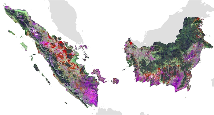
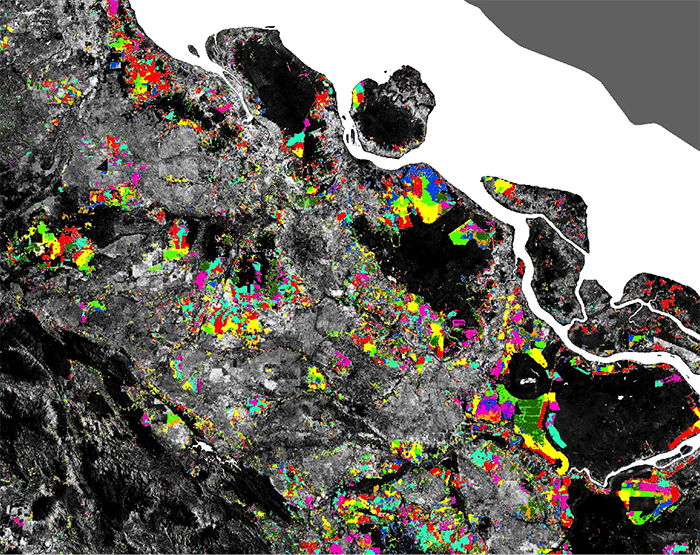

photo of workshop at LAPAN
Scholarships:
• First author paper selected for the ‘Highlights of 2011 Collection’ of Environmental Research Letters as per Journal Editors’ decision.
• Fire and Emergency Services Authority (FESA) of Western Australia Grant for the “GIS-Based Bushfire Threat Analysis of the Entire State of Western Australia” project (co-CI) [$168,000].
• University of New South Wales Start-up funds.
• German Academic Exchange Service Graduate Studies Abroad Scholarship for two semesters at the University of Hawaii, USA [$25,000].
• German Academic Exchange Service Travel Scholarship for thesis related fieldwork in Kenya [$5,000].
Publications:
Published (underlined are our lab's PhD students)
- Shendryk, I., M. Broich, M.G. Tulbure. (2018) Multi-sensor airborne and satellite data for upscaling tree number information in a structurally complex eucalypt forest. International Journal of Applied Earth Observation and Geoinformation. 73:397-406 https://doi.org/10.1016/j.jag.2018.07.011. [Download]
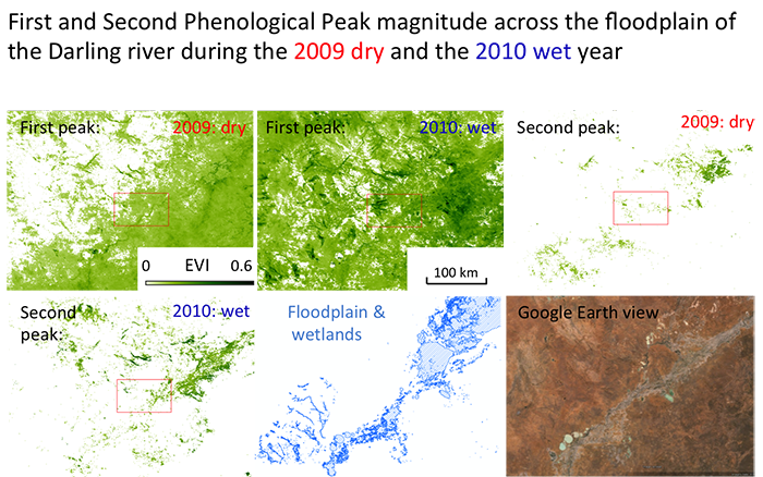
- Broich, M,. Tulbure, MG,. Verbesselt, J,. Xin Q,. Wearne, J,. (2018) Quantifying Australia's dryland vegetation to flooding and drought at sub-continental scale. Remote Sensing of Environment. 211:60-78. https://doi.org/10.1016/j.rse.2018.04.032 [Download]
- Heimhuber V, Tulbure MG, Broich, M (2018) Addressing spatio-temporal resolution constraints in Landsat and MODIS based mapping of large-scale floodplain inundation dynamics. Remote Sensing of Environment. 211:307-320. https://doi.org/10.1016/j.rse.2018.04.016 [Download]
- Bishop-Taylor, R., M. G Tulbure, M Broich (2018) Evaluating static and dynamic landscape connectivity modelling using a 25-year remote sensing time series. Landscape Ecology. 33:625–640 https://doi.org/10.1007/s10980-018-0624-1 [Download]
- Bishop-Taylor, R., M.G. Tulbure, M. Broich. (2017) Impact of hydroclimatic variability on regional-scale landscape connectivity across a dynamic dryland region. Ecological Indicators. https://doi.org/10.1016/j.ecolind.2017.07.029 [Download]
- Bishop-Taylor, R., Tulbure, M. G. and Broich, M. (2017), Surface-water dynamics and land use influence landscape connectivity across a major dryland region. Ecol Appl. Accepted Author Manuscript. doi:10.1002/eap.1507 [Download]
- Heimhuber, V., Tulbure, M.G., Broich, M. (2017) Modeling multidecadal surface water inundation dynamics and key drivers on large river basin scale using multiple time series of Earth observation and river flow data. Water Resources Research. Accepted Author Manuscript. doi: 10.1002/2016WR019858 [Download]
- Shendryk, I., M. Broich, M.G. Tulbure, A. McGrath, D. Keith and S. V. Alexandrov (2016). Mapping individual tree health using full-waveform airborne laser scans and imaging spectroscopy: A case study for a floodplain eucalypt forest. Remote Sensing of Environment 187: 202-217. [Download]
- Heimhuber, V., M.G. Tulbure and M. Broich. (2016). Modeling 25 years of spatio-temporal surface water and inundation dynamics on large river basin scale using time series of Earth observation data. Hydrology and Earth System Sciences. 20: 2227-2250. [Download]
- Tulbure M.G., M. Broich, S.V. Stehman & A. Kommareddy (2016). Surface water extent dynamics from three decades of seasonally continuous Landsat time series at subcontinental scale in a semi-arid region. Remote Sensing of Environment 178: 142–157. [Download]
- Shendryk, I., M. Broich, M.G. Tulbure & S.V. Alexandrov. (2016). Bottom-up delineation of individual trees from full-waveform laser scans in a structurally complex eucalypt forest. Remote Sensing of Environment 173: 69–83 . [Download]
- Bishop-Taylor, R., M.G. Tulbure & M. Broich. (2015) Surface water network structure, landscape resistance to movement and flooding vital for maintaining ecological connectivity across Australia’s largest river basin. Landscape Ecology. doi: 10.1007/s10980-015-0230-4. [Download]
- Broich M., A. Huete, M. Paget, X. Ma, R. Devadas, N. Restrepo-Coupe, K. Davies, A. Held. (2015). A spatially explicit Land Surface Phenology data product for science, monitoring and natural resources management applications. Environmental Modelling & Software, 64, 191-204. [Download]
- Xin Q., M. Broich, P. Zhu, P. Gong. (2015). Modelling grassland spring onset across the Western United States using climate variables and MODIS-derived phenology metrics. Remote Sensing of Environment, 161, 63-77. [Download]
- Xin Q., C. Woodcock, M. Broich, A. Suyker, P. Gong. (2015). Multi-scale evaluation of light use efficiency in MODIS gross primary productivity for croplands in the Midwestern United States. Agricultural and Forest Meteorology, 201, 111-119. [Download]
- Broich M., A. Huete, M.G. Tulbure, X. Ma, Q. Xin, M. Paget, N. Restrepo-Coupe, K. Davies, R. Devadas, and A. Held. Land surface phenological response to decadal climate variability across Australia using satellite remote sensing (2014). Biogeosciences Special Issue on Climate Extremes and Biogeochemical Cycles in the Terrestrial Biosphere: Impacts and Feedbacks Across Scales, 11 (5), 7685-7719. [Download]
- Broich, M., A. Huete, M. Paget, X. Ma, R. Devadas, N. Restrepo Coupe, K. Davies, A. Held (2014). Australian Phenology Product Dataset: A spatially explicit vegetation phenology data product for science, monitoring and natural resource management applications across Australia. AusCover TERN Sydney Node. [Download]
- Tulbure, M.G., S. Kininmonth, M. Broich. (2014). Spatiotemporal dynamics of surface water networks across a global biodiversity hotspot – implications for conservation.Environmental Research Letters, 9, 114012. [Download]
- Huete, A., Miura, T., Yoshioka, H., Ratana, P., M. Broich. (2014). Indices of Vegetation Activity. In J. Hanes (Ed.), Biophysical Applications of Satellite Remote Sensing, pp 1-41. Berlin Heidelberg: Springer.
- Tulbure M.G. and M. Broich. (2013). Spatiotemporal dynamic of surface water bodies using Landsat time-series data from 1999 to 2011. ISPRS Journal of Photogrammetry and Remote Sensing, 79, 44-52. [Download]
- Tulbure, M.G. and M. Broich. 2013. Data from: Spatiotemporal dynamic of surface water bodies using Landsat time-series data from 1999 to 2011. Dryad Digital Repository. doi:10.5061/dryad.50003 [Download]
- Xin Q., P. Gong, C. Yu, L. Yu, M. Broich, A.E. Suyker, R. Myneni. (2013). A production efficiency model-based method for satellite estimates of corn and soybean yields in the Midwestern US. Remote Sensing, 5 (11), 5926-5943. [Download]
- Ma X., A. Huete, Q. Yu, N. Restrepo Coupe, K. Davies, M. Broich, P. Ratana, J. Beringer, L. Hutley, J. Cleverly, N. Boulain, D. Eamus. (2013). Spatial patterns and temporal dynamics in savannah vegetation phenology across the North Australian Tropical Transect. Remote Sensing of Environment, 139, 97-115. [Download]
- Restrepo Coupe N., A. Huete, M. Broich, K. Davie. (2013). Phenology validation. In AusCover Good Practice Guidelines: A technical handbook supporting calibration and validation activities of remotely sensed data products, pp 8-28. Brisbane: AusCover / Terrestrial Ecosystem Research Network.
- Gaveau D., M. Kshatriya, D. Sheil, S. Sloan, E. Molidena, A. Wijaya, S. Wich, M. Ancrenaz, M.C. Hansen, M. Broich, M. Guariguata, P. Pacheco, P.V. Potapov, S. Turubanova, E. Meijaard. (2013). Reconciling Forest Conservation and Logging in Indonesian Borneo. PLOS ONE, 8 (8), e69887. [Download]
- Broich M., M.C. Hansen, P.V Potapov, M. Wimberley (2013). Patterns of tree cover loss along the Indonesia-Malaysia border on Borneo. International Journal of Remote Sensing, 34 (16), 5748-5760. [Download]
- Potapov, P.V., S.A. Turubanova, M.C. Hansen, B. Adusei, M. Broich, A. Altstatt., L. Mane, and C.O. Justice. (2012). Quantifying forest cover loss in Democratic Republic of the Congo, 2000-2010. Remote Sensing of Environment, 122, 106-116. [Download]
- Broich M., M.C. Hansen, P.V Potapov, B. Adusei, E.J Lindquist, S.V. Stehman. (2011). Time-series analysis of multi-resolution optical remote sensing imagery for quantifying forest cover loss in Sumatra and Kalimantan, Indonesia. International Journal of Applied Earth Observation and Geoinformation, 13 (2), 277-291. [Download]
- Broich M., M.C. Hansen, F. Stolle, P.V. Potapov, B.A. Margono. (2011). Remotely sensed forest cover loss reveals high spatial and temporal variation across Sumatera and Kalimantan, Indonesia 2000-2008. Environmental Research Letters, 6, 014010 [Download]
- Stehman, S.V., M.C. Hansen, M. Broich, P.V. Potapov. (2011). Adapting a global stratified random sample for regional estimation of forest cover change derived from satellite imagery. Remote Sensing of Environment, 115 (2), 650-658. [Download]
- Broich, M., Fontaine, J., & Tulbure, M.G. (2011). “A report for Fire and Emergency Services, Bushfire Protection Branch”. In, Bushfire Threat Analysis: Western Australia. Western Australia.
- Broich M., S.V. Stehman, M.C. Hansen, P.V. Potapov, Y.E. Shimabukuro. (2009). A comparison of sampling designs for estimating deforestation from Landsat imagery: A case study of the Brazilian Legal Amazon. Remote Sensing of Environment, 113 (11), 2448-2454. [Download]
Our Team
-

Associate Professor Mirela G. Tulbure
I am an Associate Professor with the Center for Geospatial Analytics.
-

PhD student Mollie Gaines
I am a PhD student with the Center for Geospatial Analytics at North Carolina State University.
-
PhD student Vinicius Perin
Hey all ! I am a PhD student at the Center for Geospatial Analytics at North Carolina State University.